[vc_row][vc_column][vc_row_inner el_class=”min100vh perfectCenter” css=”.vc_custom_1593676515197{margin-top: 0px !important;padding-top: 0px !important;background: #929397 url(https://www.ideaforge.co.in/wp-content/uploads/2020/07/Surveying-and-Mapping-Cover.jpg?id=29244) !important;background-position: center !important;background-repeat: no-repeat !important;background-size: cover !important;}”][vc_column_inner el_class=”NINJAbanner perfectCenter” css=”.vc_custom_1560859779255{margin-top: 0px !important;padding-top: 0px !important;}”][vc_column_text el_class=”NINJABannerContent perfectCenter” css=”.vc_custom_1594088924817{padding-top: 0px !important;}”]
[/vc_column_text][/vc_column_inner][/vc_row_inner][/vc_column][/vc_row][vc_row full_width=”stretch_row_content_no_spaces” css=”.vc_custom_1552233939968{background-color: #f1f1f1 !important;}” el_id=”product-submenu” el_class=”product-submenu”][vc_column offset=”vc_hidden-lg vc_hidden-md vc_hidden-sm vc_hidden-xs” css=”.vc_custom_1594088955037{padding-top: 0px !important;}”][vc_column_text css=”.vc_custom_1568975126814{margin-bottom: 0px !important;padding-top: 0px !important;}” el_class=”fixed-container”]
- Overview
- Compliance
- Tech Specs
- Payloads
- GCS
- Fail-Safes
- Applications
- Testimonials
- Downloads
[/vc_column_text][/vc_column][/vc_row][vc_row equal_height=”yes” el_class=”fixed-container overview_body NinjaSectionheight”][vc_column width=”1/2″ el_class=”NinjaSectionheight padding-right-desktop-30″][vc_empty_space][vc_column_text css=”.vc_custom_1578120353163{margin-top: 0px !important;margin-bottom: 15px !important;padding-top: 0px !important;padding-bottom: 0px !important;}”]
[/vc_column_text][vc_column_text css=”.vc_custom_1578120359613{margin-bottom: 15px !important;}”]
Fast surveying and
mapping of all-terrain
[/vc_column_text][vc_row_inner][vc_column_inner offset=”vc_hidden-lg vc_hidden-md vc_col-xs-12″][vc_single_image image=”29815″ img_size=”full” alignment=”center” css_animation=”none”][/vc_column_inner][/vc_row_inner][vc_column_text]
High-end drone surveying and mapping arms you with the ability to make fast and winning decisions using precise and well-documented visual, topographic, and heat maps of every section of your area.
Get actionable mapping insights in quick time
Get superior surveying and mapping done while saving on your resources and time. Get actionable information in quick time to direct your resources to more productive and result-oriented tasks. Align your operations to hard-data backed mapping and boost efficiency multifold.
Get high-definition composite visual mapping
Arm yourself with the foresight of highly accurate all-terrain information down to each unit area. Document each section of your terrain with live video surveillance and composite HD-image mapping within less than 1/4th manual surveying time.
[/vc_column_text][vc_empty_space height=”48px” el_class=”mobile-hidden”][/vc_column][vc_column width=”1/2″ offset=”vc_hidden-sm vc_hidden-xs” el_class=”height100″ css=”.vc_custom_1585240961347{margin-top: 0px !important;padding-top: 0px !important;}”][vc_single_image image=”29820″ img_size=”full” alignment=”center” css_animation=”none” el_class=”halfwidthimg NinjaSectionheight makeh100″ css=”.vc_custom_1594441655737{margin-bottom: 0px !important;}”][/vc_column][/vc_row][vc_row equal_height=”yes” css=”.vc_custom_1578122920011{background-color: #ffffff !important;}” el_class=”fixed-container Digital_Sky_Compliant_body NinjaSectionheight”][vc_column width=”1/2″ css=”.vc_custom_1578123113204{padding-top: 0px !important;padding-bottom: 0px !important;}” offset=”vc_hidden-sm vc_hidden-xs” el_class=”left50vwbox height100″][vc_column_text el_class=”halfwidthimg moveleft NinjaSectionheight makeh100″]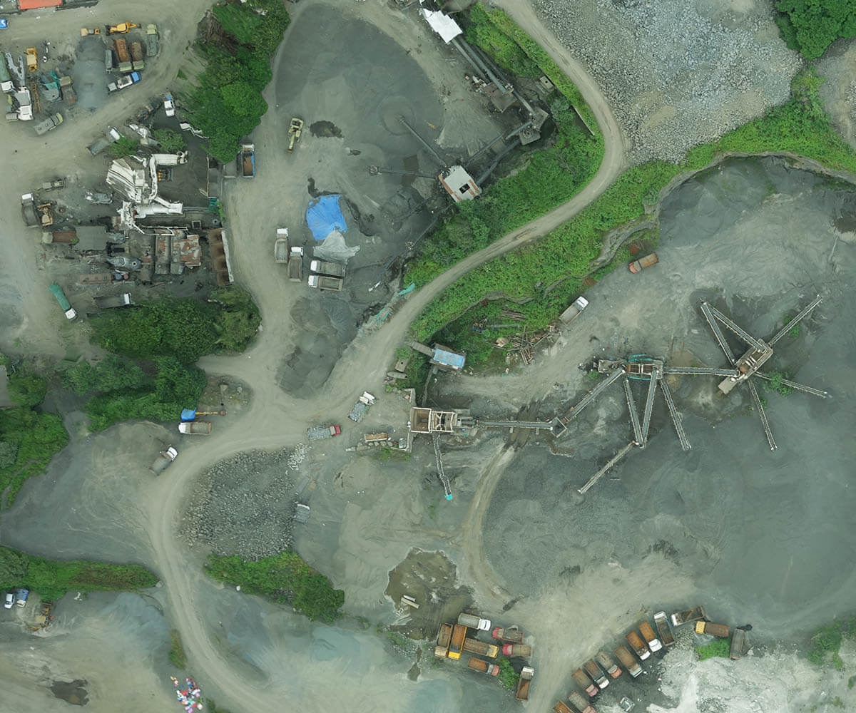

[/vc_column_text][vc_column_text css=”.vc_custom_1578129489744{margin-bottom: 15px !important;}”]
Survey docks, agriculture
lands, forests, city blocks…
[/vc_column_text][vc_row_inner][vc_column_inner offset=”vc_hidden-lg vc_hidden-md vc_col-xs-12″][vc_single_image image=”29816″ img_size=”full” alignment=”center” css_animation=”none”][/vc_column_inner][/vc_row_inner][vc_column_text css=”.vc_custom_1585240992431{margin-bottom: 30px !important;}”]
Detailed topographic visual maps inspire better decision making across multiple industries like city planning, construction, oil and gas, docks, …
Align your project planning and development with high-end surveying
Take better strategic decisions with our high-endurance drones, covering greater areas with higher accuracy in lesser time. Know which areas to develop more and where to move your resources beforehand and be totally prepared.
Track live work and movement in multiple acres within moments
Be on top of how work is progressing in real-time. Live drone-enabled video surveying helps you preempt any possible bottlenecks and defuse them before they pile on your costs. Carefully document all development and progress of your projects.
[/vc_column_text][/vc_column][/vc_row][vc_row el_class=”failsafe_body”][vc_column css=”.vc_custom_1578126138236{border-top-width: 1px !important;border-bottom-width: 1px !important;border-top-color: #f8f8f8 !important;border-top-style: solid !important;border-bottom-color: #f8f8f8 !important;border-bottom-style: solid !important;}”][vc_empty_space][vc_column_text el_class=”margin-left-negative-15″]
High-impact industrial surveying and mapping
ideaForge drones give much more actionable insights per hour using far less resources and in quick time. They have long-lasting applications from the initial exploration to final optimized operations of projects.
[/vc_column_text][/vc_column][/vc_row][vc_row equal_height=”yes” css=”.vc_custom_1578122920011{background-color: #ffffff !important;}” el_class=”fixed-container Digital_Sky_Compliant_body NinjaSectionheight”][vc_column width=”1/2″ css=”.vc_custom_1578123113204{padding-top: 0px !important;padding-bottom: 0px !important;}” offset=”vc_hidden-sm vc_hidden-xs” el_class=”left50vwbox height100″][vc_column_text el_class=”halfwidthimg moveleft NinjaSectionheight makeh100″]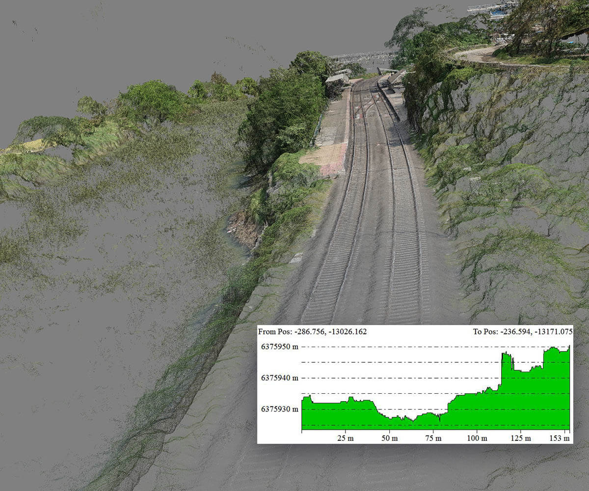
[/vc_column_text][vc_column_text css=”.vc_custom_1578129524582{margin-bottom: 15px !important;}”]
Industry-leading drone-
enabled surveying
[/vc_column_text][vc_row_inner][vc_column_inner offset=”vc_hidden-lg vc_hidden-md vc_col-xs-12″][vc_single_image image=”29817″ img_size=”full” alignment=”center” css_animation=”none”][/vc_column_inner][/vc_row_inner][vc_column_text css=”.vc_custom_1585242112453{margin-bottom: 30px !important;}”]
Faster, steadier and better flights help get a crystal-clear picture of each and every facet of the terrain. Get in-depth situational analysis, with high-grade soil and contour reading right from the sky.
Superior endurance and high-functioning drones
Deploy ideaforge drones in multiple terrains with superior IP53 ingress protection withstanding adverse climate conditions and still giving high-quality images. They fly longer to survey and map 20% more than the industrial average, consistently.
Easy to deploy and handle VTOL flights
Be on top of how work is progressing in real-time. Live drone-enabled video surveying helps you preempt any possible bottlenecks and defuse them before they pile on your costs. Carefully document all development and progress of your projects.
[/vc_column_text][/vc_column][/vc_row][vc_row el_class=”failsafe_body”][vc_column css=”.vc_custom_1578129840659{padding-top: 0px !important;padding-bottom: 0px !important;background-color: #8bc53f !important;}”][vc_column_text el_class=”margin-left-negative-15″ css=”.vc_custom_1578129873952{margin-bottom: 0px !important;}”]
Boost operational efficiency
at much lesser costs
[/vc_column_text][/vc_column][/vc_row][vc_row full_width=”stretch_row_content_no_spaces” css=”.vc_custom_1551775633573{padding-right: 0px !important;padding-left: 0px !important;}” el_id=”testimonial_body” el_class=”testimonial_body”][vc_column css=”.vc_custom_1578130053994{padding-top: 0px !important;}”][intria_section_clients t=”Customer Reviews” items=”%5B%7B%22name%22%3A%22AK%20Bhardwaj%22%2C%22company%22%3A%22-%20Commanding%20Officer%2C%20CRPF%22%2C%22content%22%3A%22%E2%80%9CThese%20(drone)%20cameras%20are%20coming%20in%20very%20handy.%20The%20picture%20quality%20is%20crystal%20clear.%20We%20are%20able%20to%20see%20over%20a%20long%20distance%2C%20and%20monitor%20movement%20accordingly%E2%80%9D%22%7D%2C%7B%22name%22%3A%22Debasish%20Roy%22%2C%22company%22%3A%22-%20Additional%20Commissioner%2C%20Kolkata%20Police%22%2C%22content%22%3A%22%E2%80%9CThe%20plan%20to%20buy%20another%20drone%20was%20mooted%20long%20ago.%20But%20its%20service%20during%20the%20Chatterjee%20International%20fire%20has%20accelerated%20the%20process.%E2%80%9D%22%7D%5D”][/vc_column][/vc_row][vc_row][vc_column][vc_raw_js]JTNDc2NyaXB0JTNFJTBBJTJGJTJBJTA5alF1ZXJ5JTI4JTIyZG9jdW1lbnQlMjIlMjkucmVhZHklMjhmdW5jdGlvbiUyOCUyNCUyOSU3QiUwQSUyMCUyMCUyMCUyMHZhciUyMG5hdiUyMCUzRCUyMGpRdWVyeSUyOCUyN2JvZHklMjclMjklM0IlMEElMjAlMjAlMjAlMjBzZXRUaW1lb3V0JTI4ZnVuY3Rpb24lMjglMjklN0IlMjAlMEF2YXIlMjB0b3Njcm9sbCUyMCUzRGRvY3VtZW50LmdldEVsZW1lbnRCeUlkJTI4JTIycHJvZHVjdC1zdWJtZW51JTIyJTI5Lm9mZnNldFRvcCUzQiUwQSUyMCUyMCUyMCUyMGpRdWVyeSUyOHdpbmRvdyUyOS5zY3JvbGwlMjhmdW5jdGlvbiUyMCUyOCUyOSUyMCU3QiUwQSUwQSUyMCUyMCUyMCUyMCUyMCUyMCUyMCUyMGlmJTIwJTI4alF1ZXJ5JTI4dGhpcyUyOS5zY3JvbGxUb3AlMjglMjklMjAlM0UlMjB0b3Njcm9sbCUyOSUyMCU3QiUwQSUwOSUwOSUwOSUwOSUwOSUyNCUyOCUyNy5oZWFkZXJfbWVudV9hcmVhJTI3JTI5LmFkZENsYXNzJTI4JTI3aGlkZW1haW5tZW51JTI3JTI5JTNCJTBBJTA5JTA5JTA5JTA5JTA5JTI0JTI4JTI3JTIzcHJvZHVjdC1zdWJtZW51JTI3JTI5LmFkZENsYXNzJTI4JTI3Y3VzdG9tLXN1Ym1lbnUtYXBwbGljYXRpb24lMjclMjklM0IlMEElMjAlMjAlMjAlMjAlMjAlMjAlMjAlMjAlN0QlMjBlbHNlJTIwJTdCJTBBJTA5JTA5JTA5JTA5JTI0JTI4JTI3LmhlYWRlcl9tZW51X2FyZWElMjclMjkucmVtb3ZlQ2xhc3MlMjglMjdoaWRlbWFpbm1lbnUlMjclMjklM0IlMEElMDklMDklMDklMjQlMjglMjcucHJvZHVjdC1zdWJtZW51JTI3JTI5LnJlbW92ZUNsYXNzJTI4JTI3Y3VzdG9tLXN1Ym1lbnUtYXBwbGljYXRpb24lMjclMjklM0IlMEElMjAlMjAlMjAlMjAlMjAlMjAlMjAlMjAlN0QlMEElMjAlMjAlMjAlMjAlN0QlMjklM0IlMEElMEElMjAlMjAlMjAlMjAlMjAlN0QlMkMlMjAzMDAwJTI5JTNCJTBBJTBBJTBBJTdEJTI5JTNCJTBBJTJBJTJGJTBBJTA5alF1ZXJ5JTI4JTI3LnNjcm9sbC1zdWIlMjclMjkuY2xpY2slMjhmdW5jdGlvbiUyOCUyOSU3QiUwQSUwQSUwOSUwOXZhciUyMGlkX2Zyb21fY2xpY2tlZCUzRGpRdWVyeSUyOHRoaXMlMjkuYXR0ciUyOCUyN2lkJTI3JTI5JTNCJTBBJTA5JTA5alF1ZXJ5JTI4JTI3aHRtbCUyQ2JvZHklMjclMjkuYW5pbWF0ZSUyOCU3QiUwQSUyMCUyMCUyMCUyMCUyMCUyMCUyMCUyMHNjcm9sbFRvcCUzQSUyMGpRdWVyeSUyOCUyMi4lMjIlMkJpZF9mcm9tX2NsaWNrZWQlMkIlMjJfYm9keSUyMiUyOS5vZmZzZXQlMjglMjkudG9wLTEwMCU3RCUyQyUwQSUyMCUyMCUyMCUyMCUyMCUyMCUyMCUyMCUyN3Nsb3clMjclMjklM0IlMEElMDklN0QlMjklMEElMDklMjAlMEElM0MlMkZzY3JpcHQlM0UlMEElMEE=[/vc_raw_js][/vc_column][/vc_row]