[vc_row][vc_column][vc_row_inner el_class=”min100vh perfectCenter” css=”.vc_custom_1600681493553{margin-top: 0px !important;padding-top: 0px !important;background: #f5ca51 url(https://www.ideaforge.co.in/wp-content/uploads/2020/09/layer-12-copy.png?id=34926) !important;background-position: center !important;background-repeat: no-repeat !important;background-size: cover !important;}”][vc_column_inner el_class=”NINJAbanner perfectCenter” css=”.vc_custom_1560859779255{margin-top: 0px !important;padding-top: 0px !important;}”][vc_single_image image=”35014″ img_size=”full” alignment=”center” el_class=”max-width-768″ css=”.vc_custom_1600756841340{margin-bottom: 0px !important;padding-top: 15px !important;padding-right: 15px !important;padding-bottom: 0px !important;padding-left: 15px !important;}”][vc_column_text css=”.vc_custom_1638467303412{margin-top: 0px !important;padding-top: 0px !important;}” el_class=”position50″]
| Up to | Over | Up to |
|
4 km
|
40 min
|
2 kg
|
|
Operational Range
|
Flight Time
|
Take-off Weight
|

[/vc_column_text][/vc_column_inner][/vc_row_inner][/vc_column][/vc_row][vc_row full_width=”stretch_row_content_no_spaces” css=”.vc_custom_1552233939968{background-color: #f1f1f1 !important;}” el_id=”product-submenu” el_class=”product-submenu”][vc_column offset=”vc_hidden-xs” css=”.vc_custom_1551584196139{padding-top: 0px !important;}”][vc_column_text css=”.vc_custom_1635165416077{margin-bottom: 0px !important;padding-top: 0px !important;}” el_class=”fixed-container”]
- Overview
- Tech Specs
- Features
- Outputs
- Payloads
- GCS
- Applications
- FAQs
- Downloads
[/vc_column_text][/vc_column][/vc_row][vc_row el_class=”fixed-container overview_body NinjaSectionheight”][vc_column el_class=”NinjaSectionheight padding-right-desktop-30″ css=”.vc_custom_1600497281915{padding-right: 0px !important;padding-left: 0px !important;}”][vc_empty_space][vc_column_text css=”.vc_custom_1600685139254{margin-bottom: 10px !important;}”]
Overview
[/vc_column_text][vc_column_text]
RYNO is ideaForge’s micro category survey-grade drone designed and specialized for mapping applications. It is equipped with an advanced mapping payload and ideaForge’s state-of-the-art- PPK module to deliver superior results. Due to its high accuracy in mapping applications, it is the only micro category drone that has been approved by the Survey of India (SOI) towards the Swamitva Yojana, which is set to be one of the largest drone-powered mapping projects in the world.

[/vc_column_text][vc_empty_space][vc_single_image image=”34321″ img_size=”full” alignment=”center” css_animation=”none” css=”.vc_custom_1600221793439{margin-top: 50px !important;margin-bottom: 0px !important;padding-bottom: 0px !important;}”][/vc_column][/vc_row][vc_row el_class=”fixed-container techspec_body NinjaSectionheight”][vc_column el_class=”NinjaSectionheight padding-right-desktop-30″ css=”.vc_custom_1600497304633{padding-right: 0px !important;padding-left: 0px !important;}”][vc_column_text css=”.vc_custom_1600685148763{margin-bottom: 10px !important;padding-bottom: 0px !important;}”]
Tech Specs
[/vc_column_text][vc_column_text css=”.vc_custom_1600855634054{margin-top: 0px !important;padding-top: 0px !important;}”]
India is a vast and diverse country. Frigid mountainous regions, hot deserts, humid plains and wetlands with torrential rains, the country has regions that represent every weather pattern and terrain conditions. Proudly Made in India, RYNO UAV has been built to withstand these demanding conditions and deliver stellar performance.
[/vc_column_text][vc_tta_accordion style=”modern” shape=”square” c_icon=”triangle” c_position=”right” active_section=”1″ no_fill=”true” collapsible_all=”true” el_class=”accordian_drop”][vc_tta_section title=”Aerial Vehicle (AV) Characteristics” tab_id=”1600062179725-3b0153ff-b225″][vc_column_text]
| UAV Weight with battery and max. payload | <2 Kg |
| Range of live transmission (LOS) | 4 km (un-obstructed & interference free) |
| Typical Cruise Speed | 10 m/s |
| Functional Temperature Range | -10°C to +50°C |
| Dust & Drizzle Resistance | IP53 rating |
| Deployment Time | <10 minutes |
| Packaging and Storage | Backpacks to carry all mission critical components |
| Regulatory Compliance | NPNT Ready – applicable for Indian airspace |
[/vc_column_text][/vc_tta_section][vc_tta_section title=”Base Station Characteristics” tab_id=”1600062179682-b4633d1e-8ee0″][vc_column_text]
| GNSS Grade | High accuracy L1 & L2 Frequency Band Enabled |
[/vc_column_text][/vc_tta_section][vc_tta_section title=”Mapping Performance at 60m AGL” tab_id=”1600073693536-7a6f64ce-a10a”][vc_column_text]
| Ground Sampling Distance (GSD) | <3 cm |
| Typical X, Y accuracy | <5 cm |
| Typical Z accuracy | <10 cm |
| Absolute X, Y accuracy | <10 cm (with 95% confidence interval) |
| Absolute Z accuracy | <20 cm (with 95% confidence interval) |
[/vc_column_text][/vc_tta_section][vc_tta_section title=”Ground Control Station (GCS) Software Features” tab_id=”1600073687515-0b7ac714-803d”][vc_column_text]
| Terrain Avoidance | Detects and avoids natural terrain by using elevation data (where available) |
| Geo Tagging |
[/vc_column_text][/vc_tta_section][vc_tta_section title=”Communication link Characteristics” tab_id=”1600073680511-2a715bb9-61da”][vc_column_text]
| Autonomous Flight Termination System or Return Home (RH) option | Return home triggered by land command on various fail safe features |
[/vc_column_text][/vc_tta_section][vc_tta_section title=”Failsafe Features” tab_id=”1600484644688-87c9f4ad-eff3″][vc_column_text]
| Multiple GPS on-board | For Redundancy |
| Auto-Return to Home and Land | On Communication Failure |
| Auto-Return to Home and Land | On Low Battery |
| Auto-Return to Home and Land | On exceeding Wind limit of the system |
| Auto-Return to Home and Land | On Battery Imbalance |
| Auto-Return to Home and Land | On exceeding Temperature limit of the system |
[/vc_column_text][/vc_tta_section][/vc_tta_accordion][/vc_column][/vc_row][vc_row css=”.vc_custom_1600502607050{border-top-width: 2px !important;background-color: #ffffff !important;border-top-color: #f9f9f9 !important;}” el_class=”features_body”][vc_column][vc_column_text el_class=”margin-left-negative-15″]
Features
[/vc_column_text][vc_row_inner equal_height=”yes” el_class=”maxwidth991″ css=”.vc_custom_1600223227281{margin-bottom: 0px !important;padding-bottom: 0px !important;}”][vc_column_inner el_class=”nomobilemargin padding-20″ width=”1/3″ css=”.vc_custom_1600223487013{margin-top: 0px !important;margin-bottom: 0px !important;}”][vc_single_image image=”35018″ img_size=”full” alignment=”center”][vc_column_text]
SOI Quality
ideaForge family of survey-grade mapping drones are qualified by Survey of India (SOI) for Swamitva Yojna
[/vc_column_text][/vc_column_inner][vc_column_inner el_class=”nomobilemargin bothborder padding-20″ width=”1/3″ css=”.vc_custom_1600223496605{margin-top: 0px !important;margin-bottom: 0px !important;}”][vc_single_image image=”34468″ img_size=”full” alignment=”center”][vc_column_text]
Superior Accuracy
<5 cm in X & Y-axis and <10 cm in Z-axis with survey-grade PPK Module
[/vc_column_text][/vc_column_inner][vc_column_inner el_class=”nomobilemargin padding-20″ width=”1/3″ css=”.vc_custom_1600223504647{margin-top: 0px !important;margin-bottom: 0px !important;}”][vc_single_image image=”34467″ img_size=”full” alignment=”center”][vc_column_text]
Robust Build Quality
RYNO airframe is built for over 2000 mapping operations
[/vc_column_text][/vc_column_inner][/vc_row_inner][vc_row_inner equal_height=”yes” css=”.vc_custom_1600225497542{margin-top: 30px !important;margin-bottom: 50px !important;padding-top: 0px !important;}” el_class=”maxwidth991″][vc_column_inner el_class=”nomobilemargin padding-20″ width=”1/3″ css=”.vc_custom_1600223514494{margin-top: 0px !important;margin-bottom: 0px !important;}”][vc_single_image image=”34459″ img_size=”full” alignment=”center”][vc_column_text]
Best-in-Class Area Coverage
Fly longer and farther for quicker ROI
[/vc_column_text][/vc_column_inner][vc_column_inner el_class=”nomobilemargin bothborder padding-20″ width=”1/3″ css=”.vc_custom_1600223523764{margin-top: 0px !important;margin-bottom: 0px !important;}”][vc_single_image image=”34791″ img_size=”full” alignment=”center”][vc_column_text]
Terrain Avoidance
Safely conduct surveying operations in tough weather and terrain conditions
[/vc_column_text][/vc_column_inner][vc_column_inner el_class=”nomobilemargin padding-20″ width=”1/3″ css=”.vc_custom_1600223534085{margin-top: 0px !important;margin-bottom: 0px !important;}”][vc_single_image image=”34781″ img_size=”full” alignment=”center”][vc_column_text]
Compliant With Air Travel
With the rating less than 100 watt hrs, RYNO battery can be hand carried in flight for easy transportation
[/vc_column_text][/vc_column_inner][/vc_row_inner][vc_row_inner equal_height=”yes” el_class=”maxwidth991 showhide” css=”.vc_custom_1600678783091{margin-bottom: 0px !important;padding-bottom: 0px !important;}”][vc_column_inner el_class=”nomobilemargin padding-20″ width=”1/3″ css=”.vc_custom_1600223487013{margin-top: 0px !important;margin-bottom: 0px !important;}”][vc_single_image image=”34783″ img_size=”full” alignment=”center”][vc_column_text]
Man-portable
75% Lighter than Drones with Similar Performance
[/vc_column_text][/vc_column_inner][vc_column_inner el_class=”nomobilemargin bothborder padding-20″ width=”1/3″ css=”.vc_custom_1600223496605{margin-top: 0px !important;margin-bottom: 0px !important;}”][vc_single_image image=”34787″ img_size=”full” alignment=”center”][vc_column_text]
Quadcopter Configuration with VTOL
Conduct operations with increased flexibility, even from smaller areas
[/vc_column_text][/vc_column_inner][vc_column_inner el_class=”nomobilemargin padding-20″ width=”1/3″ css=”.vc_custom_1600223504647{margin-top: 0px !important;margin-bottom: 0px !important;}”][vc_single_image image=”34792″ img_size=”full” alignment=”center”][vc_column_text]
Waypoint Based Navigation
Tell RYNO where to go and let it take care of the rest
[/vc_column_text][/vc_column_inner][/vc_row_inner][vc_row_inner equal_height=”yes” css=”.vc_custom_1600679308110{margin-top: 30px !important;margin-bottom: 50px !important;padding-top: 0px !important;}” el_class=”maxwidth991 showhide”][vc_column_inner el_class=”nomobilemargin padding-20″ width=”1/3″ css=”.vc_custom_1600223514494{margin-top: 0px !important;margin-bottom: 0px !important;}”][vc_single_image image=”34782″ img_size=”full” alignment=”center”][vc_column_text]
Less than 10 minutes Deployment Time
User-friendly assembly to conduct mapping operations faster
[/vc_column_text][/vc_column_inner][vc_column_inner el_class=”nomobilemargin bothborder padding-20″ width=”1/3″ css=”.vc_custom_1600223523764{margin-top: 0px !important;margin-bottom: 0px !important;}”][vc_single_image image=”34785″ img_size=”full” alignment=”center”][vc_column_text]
Minimal Training Requirements
No UAOP, Security Clearance or DGCA Training required*
*applicable in India only | under 60 m AGL[/vc_column_text][/vc_column_inner][vc_column_inner el_class=”nomobilemargin padding-20″ width=”1/3″ css=”.vc_custom_1600223534085{margin-top: 0px !important;margin-bottom: 0px !important;}”][vc_single_image image=”34786″ img_size=”full” alignment=”center”][vc_column_text]
NPNT Ready
Designed for NPNT standard
[/vc_column_text][/vc_column_inner][/vc_row_inner][vc_column_text el_class=”margin-left-negative-15″]
[/vc_column_text][vc_column_text css=”.vc_custom_1600502629657{margin-top: 50px !important;}” el_class=”outputs_body”]
Real-world Outputs
ideaForge’s commitment to produce highest quality drones ensures that our UAVs deliver consistent results across defence, homeland security and enterprise applications
[/vc_column_text][vc_column_text css=”.vc_custom_1600486343091{margin-top: 50px !important;}”]
[/vc_column_text][vc_column_text css=”.vc_custom_1600699521444{margin-top: 50px !important;}”]
Step-by-Step Execution
[/vc_column_text][vc_row_inner][vc_column_inner offset=”vc_hidden-sm vc_hidden-xs”][vc_single_image image=”35017″ img_size=”full” alignment=”center”][/vc_column_inner][/vc_row_inner][vc_row_inner][vc_column_inner offset=”vc_hidden-lg vc_hidden-md”][vc_single_image image=”35016″ img_size=”full” alignment=”center”][/vc_column_inner][/vc_row_inner][vc_empty_space height=”50px”][/vc_column][/vc_row][vc_row equal_height=”yes” el_class=”payloads_body NinjaSectionheight” css=”.vc_custom_1600502645177{margin-right: 0px !important;margin-left: 0px !important;padding-left: 0px !important;background-color: #f6f6f7 !important;}”][vc_column width=”1/2″ el_class=”NinjaSectionheight padding-right-desktop-30″ css=”.vc_custom_1600485959615{margin-right: 0px !important;background-color: #f6f6f7 !important;}”][vc_empty_space][vc_row_inner][vc_column_inner offset=”vc_hidden-lg vc_hidden-md vc_col-xs-12″][vc_single_image image=”34317″ img_size=”full” alignment=”center” css_animation=”none”][/vc_column_inner][/vc_row_inner][vc_column_text el_class=”maxwidth300 padding10″]
Payloads
The combination of mapping payload with PPK module is a powerhouse in itself. It delivers class-dominating accuracy that has never been seen before.
 |
>20Megapixel Camera |
 |
APS-C CMOS Sony Sensor |
 |
64GB Storage (Expandable) |


[/vc_column_text][/vc_column][vc_column width=”1/2″ css=”.vc_custom_1600221524861{margin-left: 0px !important;padding-top: 0px !important;padding-right: 0px !important;padding-bottom: 0px !important;padding-left: 0px !important;}” offset=”vc_hidden-sm vc_hidden-xs”][vc_single_image image=”34317″ img_size=”full” css_animation=”none” el_class=”halfwidthimg NinjaSectionheight makeh100″ css=”.vc_custom_1600221538923{margin-bottom: 0px !important;margin-left: 0px !important;padding-top: 0px !important;padding-right: 0px !important;padding-bottom: 0px !important;padding-left: 0px !important;}”][/vc_column][/vc_row][vc_row equal_height=”yes” css=”.vc_custom_1600681966239{background-color: #ffffff !important;}” el_class=”fixed-container gcs_body NinjaSectionheight”][vc_column width=”1/2″ css=”.vc_custom_1600225333707{padding-top: 0px !important;padding-bottom: 0px !important;background-color: #ffffff !important;}” offset=”vc_hidden-sm vc_hidden-xs” el_class=”left50vwbox height100″][vc_column_text el_class=”halfwidthimg moveleft NinjaSectionheight makeh100″ css=”.vc_custom_1600225419203{background-color: #ffffff !important;}”]

[/vc_column_text][/vc_column][vc_column width=”1/2″ css=”.vc_custom_1600498247368{padding-top: 0px !important;padding-right: 0px !important;padding-bottom: 0px !important;padding-left: 0px !important;}” el_class=”ninjaPaddingRightSection NinjaSectionheight”][vc_empty_space height=”50px”][vc_row_inner][vc_column_inner offset=”vc_hidden-lg vc_hidden-md vc_col-xs-12″][vc_single_image image=”34318″ img_size=”full” alignment=”center” css_animation=”none”][/vc_column_inner][/vc_row_inner][vc_column_text]
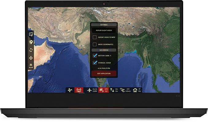
Ground Control Station
Our state-of-the-art GCS enables fully autonomous flight and provides a host of safety and security features.
- Terrain Avoidance to keep your RYNO safe
- Easy Takeoff/Landing ensures you concentrate on outcomes
- Flight Planning for predictable and repeatable mapping operations
- Geotagging software for accurate post-processing
- Live Display of Flight Parameters to keep you updated every step of the way
- Encrypted Communication for highest privacy
- Fail Safe Features for Comm Loss, Low Battery, High Winds, Temperature Range Violation
[/vc_column_text][vc_empty_space height=”50px”][/vc_column][/vc_row][vc_row css=”.vc_custom_1600502674316{background-color: #f6f6f7 !important;}” el_class=”no-container application application_body adddisplayflex” el_id=”q-series-applications”][vc_column el_class=”fixed-container”][vc_empty_space][vc_column_text el_class=”margin-left-negative-15 displayflex rynoapplication”]
Applications
RYNO UAV’s dedicated mapping payload and PPK Module make it the default choice for various mapping and surveying applications across multiple industries
[slide-anything id=”34485″][/vc_column_text][/vc_column][/vc_row][vc_row el_class=”fixed-container faqs_body NinjaSectionheight”][vc_column el_class=”NinjaSectionheight padding-right-desktop-30″ css=”.vc_custom_1600498435438{padding-right: 0px !important;padding-left: 0px !important;}”][vc_empty_space][vc_column_text css=”.vc_custom_1600229021768{padding-bottom: 0px !important;}”]
Frequently Asked Questions
[/vc_column_text][vc_tta_accordion style=”modern” shape=”square” c_icon=”triangle” c_position=”right” active_section=”1″ no_fill=”true” collapsible_all=”true” el_class=”accordian_drop_faq”][vc_tta_section title=”Is ideaForge RYNO UAV a Survey grade drone?” tab_id=”1600228833096-d20e0fdb-fca3″][vc_column_text]ideaForge RYNO UAV is a survey-grade mapping drone which meets the demands of high-accuracy mapping applications such as Land Surveying, Mining, Construction, etc. This UAV comes with an integrated PPK rover coupled with a Trimble base station that can produce X/Y accuracies better than 5 cm and Z accuracy better than 10 cm.[/vc_column_text][/vc_tta_section][vc_tta_section title=”How easy is it to fly a drone?” tab_id=”1600228833097-d4e7eda7-4c1a”][vc_column_text]The UAV performs a completely autonomous flight once the flight plan, Image Overlap, height etc are set in the UAV during flight planning.[/vc_column_text][/vc_tta_section][vc_tta_section title=”What all fail-safe features are loaded in the drone?” tab_id=”1600228833099-4c383626-17bf”][vc_column_text]In a scenario where the winds are high, battery is depleting or is imbalanced, communication loss between Ground control station and the drone, the UAV will initiate return to the same spot it took off from and land on its own without any manual intervention[/vc_column_text][/vc_tta_section][vc_tta_section title=”Do I need to get a permission for flying?” tab_id=”1600228833099-7cb96fe7-8d7f”][vc_column_text]In India, for flying any UAV, it must be compliant with DGCA’s Civil Aviation Requirements (CAR). CAR is a set of regulations that apply to any UAV that intends to fly in the Indian Airspace. Permission for flying will be digitally given by DGCA’s digital sky platform[/vc_column_text][/vc_tta_section][vc_tta_section title=”Do I need a license to fly RYNO UAV?” tab_id=”1600228833099-22c4aad9-fb07″][vc_column_text]Since ideaForge RYNO UAV is a micro category drone, you do not need a license (UAOP – Unmanned Aircraft Operator Permit) for flying the UAV till 60m of height.[/vc_column_text][/vc_tta_section][vc_tta_section title=”Can RYNO UAV be operated during rains?” tab_id=”1600399226282-3d0c5c95-c187″][vc_column_text]ideaForge RYNO UAV is an IP53 rated drone which means it is not recommended to fly the drone during rains. The UAV can handle light drizzle. Also, during rainfall, the visibility gets very poor which defeats the purpose of using drones for a mapping application.[/vc_column_text][/vc_tta_section][vc_tta_section title=”What all data is captured by the Drone and its subsystems during a flight?” tab_id=”1600401982754-50508a7a-6ff0″][vc_column_text]The Drone camera captures the images which are stored onboard the UAV. The PPK rover helps capturing the GPS data which is also stored on the UAV.[/vc_column_text][/vc_tta_section][vc_tta_section title=”Do I need to buy additional components apart from the UAV?” tab_id=”1600402023005-8e7f1f6f-c432″][vc_column_text]The drone is a complete system that is supplied to the customer and any additional components are not required. It is a ready to use system and can be used for mapping applications out of the box.[/vc_column_text][/vc_tta_section][vc_tta_section title=”How high or far can RYNO UAV fly?” tab_id=”1600402063600-2e7b1622-6ad3″][vc_column_text]The drone has been tested to achieve a height of 400 m AGL with a maximum linear range of 4 km. It can cover an area of 1 sq km in a single flight.[/vc_column_text][/vc_tta_section][vc_tta_section title=”Can I carry RYNO UAV along with batteries inside a plane?” tab_id=”1600402101967-e4e87258-7ee2″][vc_column_text]The UAV can be carried in an airplane. Since the batteries are <100WHr, they are permitted to be carried in Carry-on baggage only.[/vc_column_text][/vc_tta_section][vc_tta_section title=”How does RYNO UAV handle uneven terrain?” tab_id=”1600402133753-9abe0ae0-6652″][vc_column_text]The UAV comes with a terrain hugging feature which means that even during the uneven terrains, it maintains the height that was originally loaded during its flight plan. The UAV automatically adjusts (ascends / descends) its height with no manual intervention required.[/vc_column_text][/vc_tta_section][vc_tta_section title=”Can I change the flight plan mid-air?” tab_id=”1600402172419-c187f2de-f84a”][vc_column_text]The drone offers the feature where a new flight plan can be uploaded in between a flight operation. The UAV resumes its previous job once the new flight plan is completed.[/vc_column_text][/vc_tta_section][vc_tta_section title=”What happens if the battery depletes and the flight operation is still pending?” tab_id=”1600402200708-78bbc7c7-b362″][vc_column_text]On battery depletion, the drone will initiate home-landing on its own. Once the UAV has landed, the user can change the battery and fly it immediately to resume the flight operation from the same point.[/vc_column_text][/vc_tta_section][vc_tta_section title=”What is the time gap that I need to maintain between 2 consecutive flights?” tab_id=”1600402237876-37b65800-ce8e”][vc_column_text]You can do continuous operations by replacing the batteries. The drone does not require any cooling period after each flight.[/vc_column_text][/vc_tta_section][vc_tta_section title=”How can I plan a mapping operation using RYNO UAV?” tab_id=”1600955440628-1cf176c1-2aaa”][vc_column_text]RYNO UAV has a Ground control Station Software which allows you to plan and fly mapping missions. GCS also allows pre processing of ppk data along with images to produce geotagged images. The geo tagged information along with images can be imported to thrid party post processing software such as Pix4D, Bentley, Global Mapper, etc[/vc_column_text][/vc_tta_section][vc_tta_section title=”Does ideaForge provide any post processing software?” tab_id=”1600955542935-ce25018d-f183″][vc_column_text]ideaForge data is compatible with most software. However, the software has to be procured separately as it is not bundled with the purchase of RYNO UAV.[/vc_column_text][/vc_tta_section][/vc_tta_accordion][vc_empty_space height=”50px”][/vc_column][/vc_row][vc_row el_class=”download_body”][vc_column css=”.vc_custom_1600501635669{padding-top: 0px !important;background: #000000 url(https://www.ideaforge.co.in/wp-content/uploads/2020/09/Download-Banner-1.jpg?id=34823) !important;background-position: center !important;background-repeat: no-repeat !important;background-size: cover !important;}”][vc_column_text css=”.vc_custom_1636722656941{margin-bottom: 0px !important;}”]
Downloads
[/vc_column_text][/vc_column][/vc_row][vc_row][vc_column][vc_raw_js]JTNDc2NyaXB0JTNFJTBBJTA5alF1ZXJ5JTI4JTIyZG9jdW1lbnQlMjIlMjkucmVhZHklMjhmdW5jdGlvbiUyOCUyNCUyOSU3QiUwQSUyMCUyMCUyMCUyMHZhciUyMG5hdiUyMCUzRCUyMGpRdWVyeSUyOCUyN2JvZHklMjclMjklM0IlMEElMjAlMjAlMjAlMjBzZXRUaW1lb3V0JTI4ZnVuY3Rpb24lMjglMjklN0IlMjAlMEF2YXIlMjB0b3Njcm9sbCUyMCUzRGRvY3VtZW50LmdldEVsZW1lbnRCeUlkJTI4JTIycHJvZHVjdC1zdWJtZW51JTIyJTI5Lm9mZnNldFRvcCUzQiUwQSUyMCUyMCUyMCUyMGpRdWVyeSUyOHdpbmRvdyUyOS5zY3JvbGwlMjhmdW5jdGlvbiUyMCUyOCUyOSUyMCU3QiUwQSUwQSUyMCUyMCUyMCUyMCUyMCUyMCUyMCUyMGlmJTIwJTI4alF1ZXJ5JTI4dGhpcyUyOS5zY3JvbGxUb3AlMjglMjklMjAlM0UlMjB0b3Njcm9sbCUyOSUyMCU3QiUwQSUwOSUwOSUwOSUwOSUwOSUyNCUyOCUyNy5oZWFkZXJfbWVudV9hcmVhJTI3JTI5LmFkZENsYXNzJTI4JTI3aGlkZW1haW5tZW51JTI3JTI5JTNCJTBBJTA5JTA5JTA5JTA5JTA5JTI0JTI4JTI3JTIzcHJvZHVjdC1zdWJtZW51JTI3JTI5LmFkZENsYXNzJTI4JTI3Y3VzdG9tLXN1Ym1lbnUtYXBwbGljYXRpb24lMjclMjklM0IlMEElMjAlMjAlMjAlMjAlMjAlMjAlMjAlMjAlN0QlMjBlbHNlJTIwJTdCJTBBJTA5JTA5JTA5JTA5JTI0JTI4JTI3LmhlYWRlcl9tZW51X2FyZWElMjclMjkucmVtb3ZlQ2xhc3MlMjglMjdoaWRlbWFpbm1lbnUlMjclMjklM0IlMEElMDklMDklMDklMjQlMjglMjcucHJvZHVjdC1zdWJtZW51JTI3JTI5LnJlbW92ZUNsYXNzJTI4JTI3Y3VzdG9tLXN1Ym1lbnUtYXBwbGljYXRpb24lMjclMjklM0IlMEElMjAlMjAlMjAlMjAlMjAlMjAlMjAlMjAlN0QlMEElMjAlMjAlMjAlMjAlN0QlMjklM0IlMEElMEElMjAlMjAlMjAlMjAlMjAlN0QlMkMlMjAzMDAwJTI5JTNCJTBBJTBBJTBBJTdEJTI5JTNCJTBBJTA5alF1ZXJ5JTI4JTI3LnNob3dmZWF0dXJlcyUyNyUyOS5jbGljayUyOGZ1bmN0aW9uJTI4JTI5JTdCJTBBY29uc29sZS5sb2clMjglMjJjbGlja2VkJTIwc2hvdyUyMiUyOSUzQiUwQWpRdWVyeSUyOCUyNy5zaG93aGlkZSUyNyUyOS5yZW1vdmVDbGFzcyUyOCUyMmhpZGVtZSUyMiUyOSUzQiUwQWpRdWVyeSUyOCUyNy5zaG93aGlkZSUyNyUyOS5hZGRDbGFzcyUyOCUyMnNob3dtZSUyMiUyOSUzQiUwQWpRdWVyeSUyOCUyNy5zaG93ZmVhdHVyZXMlMjclMjkuYWRkQ2xhc3MlMjglMjJoaWRlbWUlMjIlMjklM0IlMEFqUXVlcnklMjglMjcuc2hvd2ZlYXR1cmVzJTI3JTI5LnJlbW92ZUNsYXNzJTI4JTIyc2hvd21lYmxvY2slMjIlMjklM0IlMEFqUXVlcnklMjglMjcuaGlkZWZlYXR1cmVzJTI3JTI5LnJlbW92ZUNsYXNzJTI4JTIyaGlkZW1lJTIyJTI5JTNCJTBBalF1ZXJ5JTI4JTI3LmhpZGVmZWF0dXJlcyUyNyUyOS5hZGRDbGFzcyUyOCUyMnNob3dtZWJsb2NrJTIyJTI5JTNCJTBBJTA5JTdEJTI5JTBBJTA5alF1ZXJ5JTI4JTI3LmhpZGVmZWF0dXJlcyUyNyUyOS5jbGljayUyOGZ1bmN0aW9uJTI4JTI5JTdCJTBBY29uc29sZS5sb2clMjglMjJjbGlja2VkJTIwaGlkZSUyMiUyOSUzQiUwQWpRdWVyeSUyOCUyNy5zaG93aGlkZSUyNyUyOS5hZGRDbGFzcyUyOCUyMmhpZGVtZSUyMiUyOSUzQiUwQWpRdWVyeSUyOCUyNy5zaG93aGlkZSUyNyUyOS5yZW1vdmVDbGFzcyUyOCUyMnNob3dtZSUyMiUyOSUzQiUwQWpRdWVyeSUyOCUyNy5zaG93ZmVhdHVyZXMlMjclMjkucmVtb3ZlQ2xhc3MlMjglMjJoaWRlbWUlMjIlMjklM0IlMEFqUXVlcnklMjglMjcuc2hvd2ZlYXR1cmVzJTI3JTI5LmFkZENsYXNzJTI4JTIyc2hvd21lYmxvY2slMjIlMjklM0IlMEFqUXVlcnklMjglMjcuaGlkZWZlYXR1cmVzJTI3JTI5LmFkZENsYXNzJTI4JTIyaGlkZW1lJTIyJTI5JTNCJTBBalF1ZXJ5JTI4JTI3LmhpZGVmZWF0dXJlcyUyNyUyOS5yZW1vdmVDbGFzcyUyOCUyMnNob3dtZWJsb2NrJTIyJTI5JTNCJTBBJTA5JTdEJTI5JTBBJTA5alF1ZXJ5JTI4JTI3LnNjcm9sbC1zdWIlMjclMjkuY2xpY2slMjhmdW5jdGlvbiUyOCUyOSU3QiUwQSUwQSUwOSUwOXZhciUyMGlkX2Zyb21fY2xpY2tlZCUzRGpRdWVyeSUyOHRoaXMlMjkuYXR0ciUyOCUyN2lkJTI3JTI5JTNCJTBBJTA5JTA5alF1ZXJ5JTI4JTI3aHRtbCUyQ2JvZHklMjclMjkuYW5pbWF0ZSUyOCU3QiUwQSUyMCUyMCUyMCUyMCUyMCUyMCUyMCUyMHNjcm9sbFRvcCUzQSUyMGpRdWVyeSUyOCUyMi4lMjIlMkJpZF9mcm9tX2NsaWNrZWQlMkIlMjJfYm9keSUyMiUyOS5vZmZzZXQlMjglMjkudG9wLTEwMCU3RCUyQyUwQSUyMCUyMCUyMCUyMCUyMCUyMCUyMCUyMCUyN3Nsb3clMjclMjklM0IlMEElMDklN0QlMjklMEElMDklMjAlMEElM0MlMkZzY3JpcHQlM0UlMEElMEE=[/vc_raw_js][/vc_column][/vc_row]